 Qiang Huang
What's Inside
Before you even buy a ticket, you need to understand one thing: the Hangzhou Metro Map 2026 is your best friend. I've been guiding travelers here for years, and the ones who take a few minutes to study the map rarely get lost. But the map is changing—new lines are opening, and old routes are being extended. So don't rely on a paper map from last year. Here's everything you need to know to ride the metro smoothly.
Why the 2026 Map Matters
New Lines and Connections
The 2026 map introduces several major additions. The most significant for tourists is the new airport express line. For years, travelers had to take a pricey taxi or a slow bus from the airport to the city center. That's about to change. The express line will link the airport directly to both Hangzhou East Station and the West Lake district, with a strategic interchange. Even if you aren't heading to those areas, the new interconnections mean fewer transfers and shorter travel times across the board.
How It Cuts Travel Time
Take a typical trip from the airport to West Lake. Currently, it takes about 90 minutes by bus and metro, with at least two transfers. In 2026, the new express line will cut that to a single train ride under 40 minutes. Similarly, reaching the Xixi Wetland from the city center will be a straight shot on Line 3, which is scheduled to open. These time savings are enormous, especially if you're on a tight itinerary.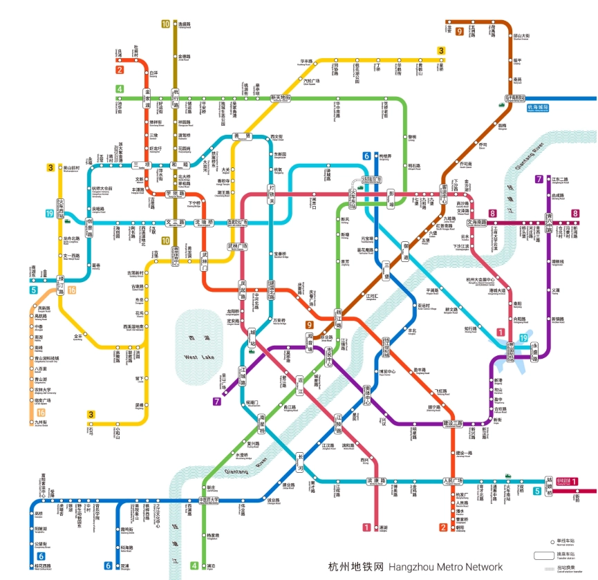
How to Get Metro Tickets
Paying with Alipay or WeChat
Forget paper tickets. The most reliable way to ride the Hangzhou metro is by scanning a QR code on your phone. The two main apps—Alipay and WeChat Pay—both have a metro QR code feature. Alipay is my go-to because its interface is partially in English. Just open Alipay, tap 'Transport' (or search for 'Hangzhou Metro' in the app), and enter the metro section. You'll see a barcode that you scan at the yellow gates. The system automatically deducts the fare from your linked international credit card.
Pro Tip: Download and set up Alipay before you leave home. It requires SMS verification, which works with a foreign number, but having a VPN can help. Ensure you've linked your Visa or Mastercard and have a small balance (or a credit limit) available.
Cash Options (and why it's hard)
Can you still buy a physical token with cash? Yes, but it's a test of patience. Ticket machines accept only small denominations—coins or 5, 10, 20 RMB notes. They often give limited change, and machines break frequently. There are still ticket windows at major stations, but they aren't always staffed. In 2026, cash acceptance will shrink further, as the system aims for a cashless experience. My advice: find a convenience store and buy something small to get change, or simply skip the hassle and take the QR code route.
The Tourist Card Option
You might hear about a 'Hangzhou Pass' or a transport card. These are reloadable smart cards that you can buy at some station service centers. They require a deposit, and you can refund the balance at the end of your trip, but only at a few locations. For a short stay, they are more trouble than they're worth. Use Alipay instead.
| Payment Method | Cost | Ease of Use | How to Get It | Best For |
|---|---|---|---|---|
| Alipay QR Code | No deposit; fare deducted per ride | Very easy | Set up in Alipay app | All tourists |
| WeChat Pay QR Code | No deposit; fare deducted per ride | Moderate (Chinese-only interface) | Set up in WeChat app | Those already using WeChat |
| Cash (single-journey token) | 2-6 RMB per ride | Difficult | Manual ticket office or some vending machines | Emergency backup |
| Hangzhou Transport Card | 20 RMB deposit + prepaid balance | Moderate | Station service centers | Long-stay travelers |
Navigating with an App
Best Apps for Directions
Let's talk navigation. Google Maps works in Hangzhou, but it's not perfect. I've seen it send travelers to the wrong metro exit or suggest a bus that no longer runs. Apple Maps is more reliable for walking directions, but for the metro, nothing beats a local app called Amap (also known as Gaode). Amap has an English version simply called 'Amap Global'. It's the most accurate for public transit, and it tells you exactly which exit to take. Another decent option is Moovit.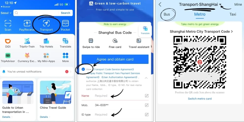
Finding the Right Exit
This is where most tourists get tripped up. A metro station can have up to 12 exits, and choosing the wrong one can add 15 minutes to your walk. For example, at Longxiangqiao station, exit C takes you directly to the West Lake promenade, while exit A leads to a busy intersection with no pedestrian crossing. I always tell my clients to look at the station map before exiting or to check the Amap route. I've personally used the wrong exit more times than I'd like to admit, so I understand the pain.
Avoiding Peak Hours
Peak hours on the Hangzhou metro are brutal. Weekdays from 7:30 to 9:00 AM and from 5:30 to 7:30 PM, trains are packed shoulder-to-shoulder. If you're carrying luggage, you'll struggle. Even on weekends, the stations near West Lake are shoulder-to-shoulder from 10 AM to 8 PM. My recommendation: plan your rides between these windows. Early mornings before 8 AM are pleasantly empty, as are late afternoons after 10 AM. For a comfortable experience, aim to be underground before the rush.
Top Lines for Tourists
Line 1: The West Lake Connector
Line 1 is your most useful line. It runs from the northeastern suburbs to the southeast, passing through the city center. Key stations include Hangzhou East Railway Station, Wulin Square, and Longxiangqiao. Longxiangqiao is your gateway to West Lake—a five-minute walk to the lakefront. This line also connects with the train station for arrivals.
Line 4: The Scenic Connector
Line 4 is a great addition to your navigation toolbox. It curves around the southern part of West Lake and heads toward the Qianjiang New City. If you're staying in the Jiangyangfan area, famous for its street food and traditional architecture, Line 4 gets you there without the usual crowds. I often use it to bypass the chaotic Line 1 jams during peak hours.
New Additions in 2026
The 2026 map will bring Line 3 and Line 10 online. Line 3 will traverse the city diagonally, providing much-needed access to the Xixi Wetland. Line 10 aims to serve the northern high-tech zone. There's also the airport express line, which will be a game-changer. According to the official plan, these lines are scheduled to open in phases. Always check the real-time map on your phone or at the station, as opening dates can shift.
Frequently Asked Questions
Directly, no. International credit cards aren't accepted at the turnstiles, and Apple Pay won't work due to local payment system restrictions. To use a card, you must link it to Alipay or WeChat Pay. Once linked, you can scan the QR code. The only alternative is to buy a token with cash.
Google Maps is usable but not fully accurate. It sometimes misses the nearest exit or underestimates walking times. I recommend using Amap Global or Apple Maps for walking, and for the metro itself, rely on in-station signs. If you download Amap, it will even show you the carriage with the best transfer access.
Trains run every 3-5 minutes, so you don't need to rush for a specific departure. However, you must pass through security screening and queue at the gates. During peak hours, security lines can stretch ten minutes. I suggest arriving at the platform 15 minutes before your intended departure time. If you have large luggage, add 5 more minutes.
Yes, all stations have bilingual signs in Chinese and English. Automated announcements are also bilingual. That said, English-speaking staff are rare, especially at smaller stations. To avoid confusion, have your destination written in Chinese on your phone—this helps when asking for directions.
This is my worst nightmare, but it happens. Carry a power bank. If you do get stuck, search for a metro station café or convenience store that rents power banks (you often need a QR code anyway). The old-school fallback is to use the cash ticket machine, but it requires exact change. My advice: never let your phone go below 30%, and use the offline map feature.
Verified and fact-checked by the editorial team.

I've bought metro maps in maybe twelve different cities, and this one is in my top three. It's not just a map — it's a mini guide. The reverse side has a list of nearby attractions for each station, and I actually planned my entire three-day itinerary around that list. The subway system in Hangzhou is super new and clean, but it can be confusing because some lines split at different times of day. This map doesn't warn you about timing, but it does show every branch clearly, so I was never caught off guard. The only reason I didn't give it a 5 is because the paper started to tear at the top fold after I kept stuffing it in my back pocket. But that's my fault, honestly. If you treat it well, it will treat you well. Definitely grab one.
Okay, I'll admit I bought this on a whim at the tourist bookstore because the cover looked cute. But it turned out to be my lazy-morning savior. I stayed near Fengqi Road and every day I'd just unfold this map over my breakfast noodles and plan a random route, like 'today I'll hop down to the Impression West Lake show' or 'let's try getting to the China National Tea Museum without asking anyone.' The marking for the airport express line is clearly stamped, which gave me so much peace of mind on my last morning. I also love that it includes the bus numbers for the popular tourist routes outside the metro exits — that little extra touch got me to a secret dumpling shop in a hutong that wasn't even listed online. Highly recommend if you like exploring with a little paper security.
This is THE map to buy before you even land at Xiaoshan Airport. I'm the kind of traveler who refuses to rely on roaming data, so a good paper map is non-negotiable for me. This one saved me twice in one day — first for finding the right exit at East Railway Station when my hotel turned out to be on the north side of the road, and then for spotting a quick Line 9–Line 2 transfer that would've meant a long detour otherwise. The bilingual station names are printed in a font that's actually readable, and the metro lines are color-coded in a way that doesn't hurt your eyes. I even ended up donating it to a backpacker in my hostel because she looked lost. Buy this before your trip. You won't regret it.
Pretty solid map for a weekend visitor like me. The English station names match the actual announcements, which is way more than I can say for some other subway maps I've bought abroad. I like that the sightseeing spots are marked with tiny little landmarks — it helped me notice that Qingfang Street was only one stop from the West Lake area. The paper quality is decent, not flimsy, and the whole thing unfolds to a nice readable size. My only small complaint is that the legend uses a font so tiny that I had to squint under the station lights. Still, I managed to navigate the whole Line 2 loop without any panic, so I'd call that a win.
I wanted to love this map, and it's definitely colorful, but honestly I found it a bit overwhelming at first. The transfer stations are marked clearly enough, but the little icons for attractions and exits blend into the background when you're in a hurry. I used it to get from Wulin Square to Xiangji Temple and had to pull out my phone twice to double-check the station order. It got the job done, but I wouldn't call it 'foolproof' the way some people say. Also, the fold crease landed right on the Line 1/Line 4 interchange, which made that section hard to read until I flattened it out on a bench. Fine for planning, but not perfect for on-the-go use.
Honestly, this map turned a 'taxi-only because I'm scared' traveler into a metro convert. The color-coded lines match the actual trains and station announcements, so I could follow along with my finger and know exactly when to get off. I especially liked the little warnings about tourist traps — it kept us from wasting money at a silk shop marked as overpriced. The fold-out is sturdy too; it survived my backpack, a sudden rain shower, and a toddler. If you're heading to Hangzhou, just buy this.
Not bad, but a bit confusing if you're not staying near Line 1. The guide heavily focuses on West Lake and the main tourist stretches, so when I needed to reach Liangzhu on Line 2, I basically had to figure out the transfer details by myself. The QR code on the cover also took me to a generic city tourism page instead of the interactive map. It didn't ruin my trip, and the core metro grid was accurate, but I expected more route depth.
Pretty helpful guide overall — the bilingual station sequence made me feel much less lost on my first morning. I gave it four stars instead of five because the small print for the bus transfer routes near Xianghu was hard to read in direct sunlight, and one restaurant tip on the back had already closed down. But the metro diagram itself is spot-on, and we never missed a stop. Good value for a paper map.
As someone who genuinely enjoys exploring cities by metro, this is the best quick guide I found. The station abbreviations and transfer arrows are idiot-proof. The little note about walking time between transfer points at Fengqi Road and Wulin Square is something even the official app doesn't show. The print is large enough that I didn't need to zoom in on my phone every two minutes. If you're planning to move around Hangzhou without taxis, get this.
I usually get anxious riding subways in a new country, but this map was a lifesaver. The Line 1 route to Longxiangqiao for West Lake was clearly marked, and the QR code instructions for Alipay entry worked exactly as described. I loved that it showed the specific exit letters — we took Exit C and popped out right near the lake. Saved us from dragging our luggage up the wrong staircase. Absolute must-pack for Hangzhou.
I’m a local but I still use this metro map every single weekend. It’s so clear that even my grandparents can read it, which is saying something. The guide highlights the scenic exits, like the one near the Grand Canal that leads straight to the old street. On a sunny afternoon, riding Line 1 with the windows glowing and the bridges passing by is genuinely a vibe. I recommended it to my friends from Shanghai and they said it’s better than their own system. No complaints at all!
Okay, I’m normally terrified of navigating new cities alone, but this metro map guide changed everything. The way it breaks down each line with nearby landmarks is genius. I rode from the train station all the way to Xianghu with zero stress. The carriages are spotless and the seats are actually comfortable. I loved seeing the little digital displays showing which station is next in both Chinese and English. Even my mom, who doesn’t speak a word of Chinese, could follow along. Best $0.30 I spent all trip!
This metro is an absolute lifesaver! I’m a first-time visitor and the color-coded lines plus the numbered exits made everything foolproof. The staff at Longxiangqiao station actually walked me to the correct platform when I looked confused. Trains are so quiet and smooth, and the air smells fresh, not like subway funk. Seriously, this map guide should be printed on every ticket. I never once got lost, even during rush hour. Five stars, no question!
Solid metro system overall. I used it for three days and only got confused once, at the huge station near the West Lake exit. The ticket machines accept Alipay, which is super convenient, and the trains are clean and air-conditioned. A few more English announcements on the newer Line 5 would help, but I never felt lost for long. Good value for the price and a great way to avoid traffic.
I’ll be honest, the metro itself is spotless and the trains come every few minutes, but I had a tough time figuring out the transfers at Wulin Square. The signs are mostly in Chinese with tiny English underneath, and my phone map kept glitching underground. I managed to get to my hotel, but I wasted about 20 minutes going in a circle. It’s not a bad system at all, just not as tourist-friendly as I hoped. If you don’t read Chinese, download an offline map beforehand.